


GOP presidential candidate and Florida Gov. Ron DeSantis declared a state of emergency Saturday for much of his state, as a possible tropical storm brewed in the Gulf of Mexico.
The National Hurricane Center said Tropical Storm Idalia formed Sunday in the Gulf of Mexico on a potential track to come ashore as a hurricane in the southern U.S.
DeSantis issued an executive order with the emergency declaration for 33 counties in preparation for the storm initially known as Invest 93L, saying it was expected to strengthen into a tropical storm in the coming days.
The governor and the Florida Division of Emergency Management “are taking timely precautions to ensure Florida’s communities, infrastructure and resources are prepared, including those communities that are still recovering following Hurricane Ian,” the governor’s office said.
“I signed an Executive Order issuing a state of emergency out of an abundance of caution to ensure that the Florida Division of Emergency Management can begin staging resources and Floridians have plenty of time to prepare their families for a storm next week,” DeSantis said in a statement. “I encourage Floridians to have a plan in place and ensure that their hurricane supply kit is stocked.”
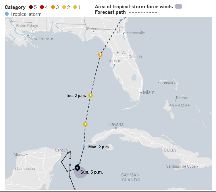
At 11:15 a.m. Sunday, the storm was located about 80 miles east-southeast of Cozumel, Mexico, moving east at 2 mph with highest sustained winds of 40 mph, forecasters said. Hurricanes have winds of 74 mph and above.
Forecasters said they expected Idalia to become a hurricane on Tuesday in the Gulf of Mexico and then curve northeast toward the west coast of Florida. Initial forecasts indicated that could come ashore on Wednesday as a Category 1 hurricane.
The governor’s office noted Saturday how the forecast currently places a tropical storm or hurricane making landfall along Florida’s Gulf Coast early – mid next week, “with the potential for heavy rainfall, strong winds, and for isolated tornadic activity.”
The 33 of the state’s 67 counties are covered in the declaration are: Alachua, Bay, Calhoun, Charlotte, Citrus, Columbia, DeSoto, Dixie, Franklin, Gadsden, Gilchrist, Gulf, Hamilton, Hardee, Hernando, Hillsborough, Jefferson, Lafayette, Lee, Leon, Levy, Liberty, Madison, Manatee, Marion, Pasco, Pinellas, Polk, Sarasota, Sumter, Suwannee, Taylor and Wakulla.
Jamie Rhome, deputy director of the National Hurricane Center, said in an update on Sunday that residents in the Tampa, Fla., area should expect strong winds by Tuesday morning, and that storm preparations should be completed by Monday night.
“This portion of the Florida peninsula is very storm surge-vulnerable,” he said of the northwest part of Florida. “It will not take a strong system or a direct hit to produce a significant storm surge.”
He said the storm could become a hurricane by the time it reaches western Florida on Tuesday, with winds projected to be up to 90 miles per hour. Idalia threatens to strengthen in the Gulf, but forecasters are not sure exactly how quickly or by how much.
The Florida Division of Emergency Management told residents to keep their gas tanks halfway full in case emergency evacuation orders were issued.
The state mobilized 1,100 members of the National Guard, which has 2,400 high-water vehicles and 12 aircraft ready for rescue efforts. Electric companies will have workers on standby starting on Monday.
The Hurricane Center noted in an advisory on Sunday, when the storm was still designated as a tropical depression, that from Tuesday into Wednesday, parts of the west coast of Florida, the Florida Panhandle and southern Georgia could get up to six inches of rain, with higher isolated totals of 10 inches.
“There is an increasing risk of life-threatening storm surge, flooding from heavy rainfall and hurricane-force winds along portions of the west coast of Florida and the Florida Panhandle beginning as early as Tuesday,” the center said.