

As the Midwest gears up for potential blizzard conditions, millions of Americans are also preparing for a bitter blast of arctic air dropping in from Canada that’s set to plunge temperatures well below zero, setting the stage for a dangerous and potentially life-threatening stretch of winter weather conditions.
The FOX Forecast Center says temperatures in the southern Plains will drop to levels that haven’t been seen since the Great Freeze of February 2021.
How cold will it get?

Temperatures over the weekend and into the start of the new workweek are going to be downright brutal, with low temperatures reaching well below zero and daytime highs struggling to make it to zero.
By Saturday morning, temperatures in the western U.S. could plummet to between 20 and 30 degrees below zero, including cities such as Missoula and Billings in Montana and Casper in Wyoming.
In the central and northern Plains, temperatures could drop between 10 and 15 degrees below zero.
Dangerous wind chills likely

Wind chill alerts have been issued across the West and Plains in advance of the frigid air pushing into the region.
Wind Chill Warnings are also expanding in coverage as wind chill values could drop to as much as 65 degrees below zero.
Wind Chill Advisories and Wind Chill Watches have also been posted due to the mix of cold air and strong winds forecast across the region.
The dangerous wind chills are likely starting Friday, with the potentially life-threatening cold from the Intermountain West to the central and southern Plains.
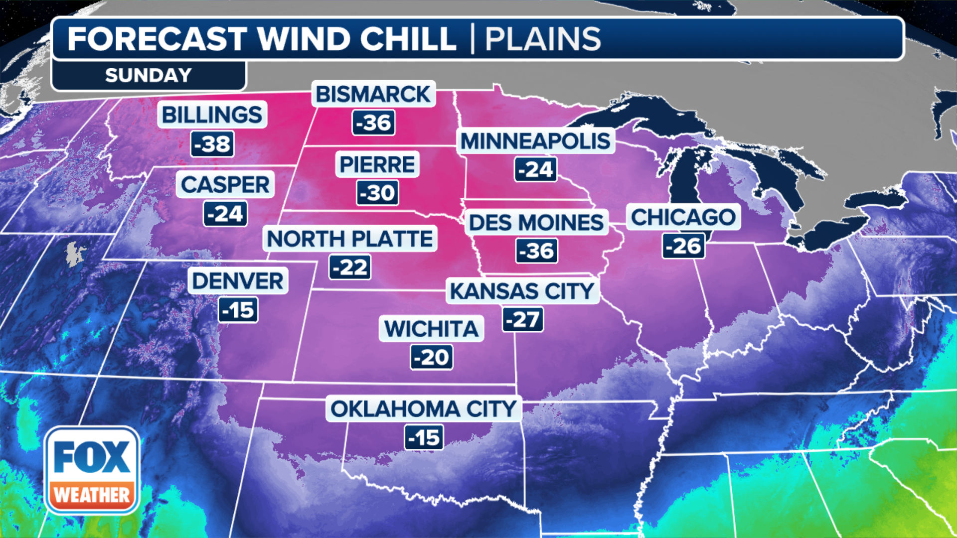
Even the Midwest will get in on the action, with cities such as Kansas City, Missouri, seeing wind chill values of about 14 degrees below zero.
The dangerous wind chills will push farther east as the weekend ends and a new workweek begins.
Chicago, for example, will see a wind chill value of about 26 degrees below zero by Sunday.
Temperature outlook

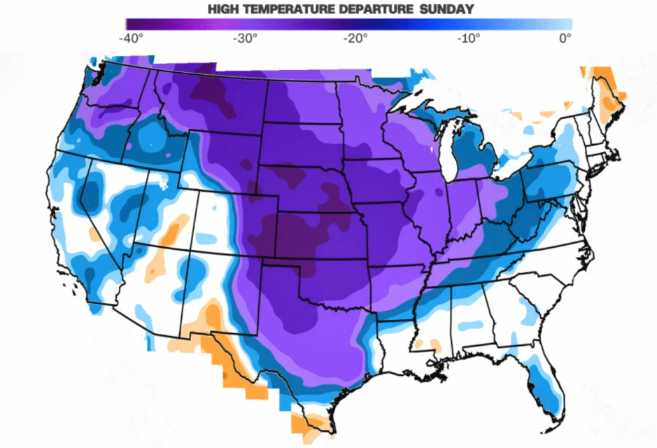
The temperature outlook from the Climate Prediction Center shows well-below-average temperatures through Minneapolis, Kansas City, Little Rock in Arkansas, Nashville in Tennessee and Chicago through Jan. 18.
The Electric Reliability Council of Texas (ERCOT) warned of strains to their electric system from high heat demand next week in advance of the cold snap dropping temperatures to freezing.
“ERCOT has issued a Weather Watch from January 15–17 due to forecasted extreme cold weather across the ERCOT region, higher electrical demand, and the potential for lower reserves,” the company managing the power grid said in a statement. “Grid conditions are expected to be normal and can be monitored on http://ercot.com.”
On Thursday, ERCOT posted an update on X, formerly Twitter, and said it continues to monitor the winter weather moving in and would deploy all available tools to reliably manage the grid. In the update, ERCOT said there isn’t a current expectation of an energy emergency.
Why has the winter been mild, and what is changing that?
El Niño is partly to blame for the mild winter so far in the U.S. During an El Niño winter, the temperatures in the northern U.S. are usually warmer and drier than average, according to NOAA. The jet stream generally flows more west to east.
“So we were pretty lucky for a good chunk of the month of December and even into the very beginnings of January, but now it’s been a kind of page turn, if you will, a complete flip of the script,” FOX Weather Meteorologist Kendall Smith said. “Because now we’re starting to see that cold air that has been locked in place over Canada and over the Arctic. That’s going to be starting to change.”

About two weeks ago, the Arctic underwent minor, sudden stratospheric warming. Air in the stratosphere, a layer in Earth’s atmosphere about 19 miles above the surface, warmed by 55 degrees in a six-day period, wrote Amy Butler of NOAA’s Chemical Sciences Laboratory. That slowed the polar vortex winds.
About every other year, weather events in the lower atmosphere send strong atmospheric waves into the stratosphere, which interact with the polar vortex.
The polar vortex is a band of strong winds circling the North Pole. A constant, stable spin of those winds keeps the arctic air locked in place. When the winds slow and become unstable, just like a top, the vortex wobbles. Stratospheric weather leads our weather by as much as two weeks, according to Judah Cohen, Atmospheric Scientist from Verisk Atmospheric and Environmental.

“A disruption of the polar vortex called a sudden stratospheric warming, where you have a very dramatic warming at the North Pole in the stratosphere, and the polar vortex then migrates south, off where it’s normally positioned on the North Pole, to the south,” said Cohen. “And the cold air then is able to move south and then, at the surface, that often will manifest itself in a negative Arctic oscillation.”
During the Great Texas Freeze in February 2021, the Arctic oscillation was at its lowest, most negative, reading in eight years. Nor’easters are also linked to the negative Arctic oscillation phase, according to NOAA.